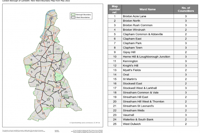
Following the Local Government Boundary Commission for England’s (LGBCE) review of Lambeth’s electoral wards, the council adopted new wards from the 5 May 2022 local elections.
To find out more about the LGBCE’s electoral ward boundary review, please visit the Electoral ward boundary review
You can also see a digital map of all the wards.
In the table below you will find links to Lambeth’s ward maps.
| Lambeth Wards from 5 May 2022 | Size |
|---|---|
| Brixton Acre Lane Ward Map | 2.80 MB |
| Brixton North Ward Map | 2.46 MB |
| Brixton Rush Common Ward Map | 3.48 MB |
| Brixton Windrush Ward Map | 2.10 MB |
| Clapham Common and Abbeville Ward Map | 3.42 MB |
| Clapham East Ward Map | 3.35 MB |
| Clapham Park Ward Map | 3.22 MB |
| Clapham Town Ward Map | 3.00 MB |
| Gipsy Hill Ward Map | 4.58MB |
| Herne Hill and Loughborough Junction Ward Map | 5.97 MB |
| Kennington Ward Map | 3.22 MB |
| Knights Hill Ward Map | 4.92 MB |
| Myatts Fields Ward Map | 2.38 MB |
| Oval Ward Map | 2.98 MB |
| St Martin's Ward Map | 3.39 MB |
| Stockwell East Ward Map | 2.60 MB |
| Stockwell West and Larkhall Ward Map | 4.22 MB |
| Streatham St Leonard's Ward Map | 5.10 MB |
| Streatham Wells Ward Map | 2.94 MB |
| Streatham Common and Vale Ward Map | 6.43 MB |
| Streatham Hill East Ward Map | 2.86 MB |
| Streatham Hill West and Thornton Ward Map | 2.75 MB |
| Vauxhall | 2.69 MB |
| Waterloo & South Bank Ward Map | 3.11 MB |
| West Dulwich Ward Map | 4.25 MB |
Image

